Last night's unusual derecho weather produced strong winds and rain. If you're like most people, you're probably wondering what a derecho is. I certainly was when I heard my local weather forecaster Dave Dahl mention derecho-like weather predictions yesterday.
 |
| Image Source |
A derecho is a widespread, long-lived, straight-line wind storm that is associated with a land-based, fast-moving band of severe thunderstorms. Derechos can carry hurranic or tornadic force and often deliver torrential rains and perhaps flash floods as well as strong winds. Winds convection-induced take on a bow echo(backward "C") form of squall line, forming in an area of wind divergence in upper levels of the troposphere, within a region of low-level warm air advection and rich low-level moisture. They travel quickly in the direction of movement of their associated storms, similar to an outflow boundary (gust front), except that the wind is sustained and increases in strength behind the front, generally exceeding hurricane-force. ~ http://en.wikipedia.org/wiki/Derecho
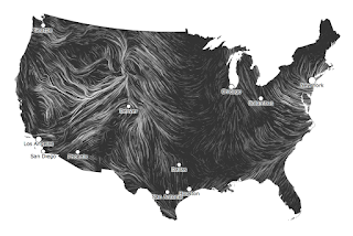
What a great opportunity to take advantage of an interesting and fun Web 2.0 website called Wind Map. http://hint.fm/wind/
 |
| Image Source |
Wind Map is a personal art project created off hourly updates to surface wind data from the National Weather Service National Digital Forecast Database (http://ndfd.weather.gov/technical.htm).
 |
| Image Source |
Some of the great features of the wind maps include being able to hover over a region and get a pop-up of the wind speed at a particular latitude and longitude. Clicking on a area of the map creates a zoomed in view, which can produce some great visuals for teaching meteorological concepts.
 |
| Image Source |
No comments:
Post a Comment